93 Photo Street Frequently Asked Questions
For general photo mapping questions, see the Photo Map FAQ
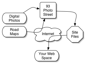
93 Photo Street is a tool for making web photo maps.
93 Photo Street runs on Windows 2000 or XP, and also on Mac OS X 10.3 (Panther) or higher.
For Windows, we recommend at least a 1.0GHz PC with 512MB of RAM. For OS X, we recommend at least a 800MHz G4 with 512MB of RAM.
The 93 Photo Street application takes less than 35MB of hard drive space, but you will need additional space for your image files and the web site files which you will create with 93 Photo Street.
Your computer MUST be able to connect to the Internet and download free map data files over the web. An Internet connection and web space are not included with 93 Photo Street.
93 Photo Street creates web site files on your local hard drive, which you can then upload to any sort of web space. If your ISP provides web space, you can use their tools to publish your photo map there. There are also free web spaces (like geocities) which allow you to publish your files on the web.
You can publish photo maps to TypePad blogs and to MovableType 3+ servers.
The web pages which display your photo maps are created using Velocity templates, which you can edit to change the look and feel of your web site.
93 Photo Street gives you the ability to overlay your own map images on the road map data. Whether you have topo maps, floorplans or trail maps, you can incorporate them into your web photo maps. In addition, PNG images with transparency will show the underlying road data, so you can use non-rectangular and semi-transparent maps.
93 Photo Street currently reads JPEG files for location images because almost all digital cameras write that format. If you have other formats, there are many conversion applications out there which can quickly convert a directory of images to JPEG files.
93 Photo Street currently reads JPEG, GIF, and PNG files for map images images. Transparency in PNG files will be used in 93 Photo Street, so if you use PNGs in conjunction with road data they can display non-rectangular shapes over roads.
The National Association of Counties provides a
free county search page which you can use to find the counties near any city in the U.S.
When you build your photo map web site you will need to enter the "base URL" of where your site will be published on the web.
For example, if your map ends up at http://somewhere.com/Athens/index.html then your "base URL" would be http://somewhere.com/Athens/ and that is what should be entered in the "base URL" field on the "Build Site" window.
In the 93 Photo Street map editor, use the "+" and "-" buttons to zoom in and out and drag the map to pan it in any direction. To quickly zoom to a region, hold down shift and select the region of interest.
The United States Census Bureau created a database of roads and and other geographic features in order to facilitate their monumental task of tracking down every man, woman, and child and asking them to fill out a short questionnaire. Because U.S. taxes paid for the map data, it makes sense that they would not charge for it a second time. That logic apparently doesn't apply in other parts of the world, or there would be international versions of 93 Photo Street.
Many of the map images are "background images", which many browsers will not print by default. Check your browser settings for a "print background images" option to solve this problem.